
Click on a project name or scroll down.
Bagley Field, Bagley Bridge to Exit 8, Exit 8 Project, East Main, Warner Story Walk, Exit 9

(See headings below for specific projects.)
Bagley Field & Bagley Bridge
Bagley Field was our first section of Rail Trail and continues to see daily use years after opening in 2014. That 1/2 mile section was lengthened to 8/10 of a mile in 2017 with a project that included the re-decking of a 100′ bridge over the Warner River. You will also find a Dero Fixit Station next to the Kiosk at Bagley. This includes a bike pump and tools to make basic adjustments to a bike.
Download this map of the Bagley Trail Segment.
Bagley Bridge to Exit 8
To extend the rail trail toward the village required gaining access to land that was in 2014 owned by New Hampshire Department of Transportation. It was purchased by NHDOT as part of the construction of I-89. The Friends of the Concord-Lake Sunapee Rail Trail worked with the Town of Warner to petition NHDOT and the Federal Highway Administration to declare the land surplus. This process concluded successfully in 2021 and once the land was in town ownership FCLSRT requested an easement from the town over the portion of the land that had the railroad grade. That request was granted. We now have the opportunity to develop another half mile of trail that leads to a beautiful view of the Warner River near I-89 Exit 8. We applied two years in a row for Recreational Trails Program funding and were not successful in getting the grant as these are very competitive and they prefer projects that complete connections. In 2023 we applied to Merrimack County for funding through a one time ARPA (American Rescue Plan Act) funded grant program. We received notice on 9/1/2023 we were awarded $74,311 for this project. This project leads up to the larger Exit 8 Project that will get the trail to the village. We will do what preparation work we can with volunteers and complete this work as soon as possible. People getting on I-89 at Exit 8 will see this project to the right of the highway between Exit 8 and Bagley Field.
12/2/24 Update: This section of trail opened in November of 2024. Another special shout out to Merrimack County who made an additional allocation of funds bringing their total contribution to $100,000 for this project. Construction costs had escalated since we initially applied for funding.


The Exit 8 Project
Shown below as an orange line in the center of the image is the Exit 8 Project. (Just an approximation of where it may be.) Starting at the lower right corner of the picture, shown in blue, is part of the existing rail trail at Bagley Field and Bagley Bridge which were built in 2014 and 2017. Next the yellow line is the half mile extension project Bagley Bridge to Exit 8. Orange is the Exit 8 project. More on that in a moment. On the left edge of the picture in red is the 136 & 174 E Main Project.

If you look closely you see almost all of the Exit 8 Project is located in the median of I-89. There are many technical and environmental challenges. In October of 2013 we gathered a group of Federal Highway, NH Department of Transportation, Central NH Regional Planning, Warner Selectboard, Warner Conservation Commission and others to walk the route. We wanted to know if we could ever be given permission to put in a trail connecting Bagley Field to the village. That field report is available here.
In mid-2021 the Town of Warner applied to Senator Jeanne Shaheen for Congressionally Directed Spending for this project and several others in town including the Exit 9 rail trail project. None of these requests made it into the final fiscal 2022 federal appropriations bill.
In January of 2023 The Friends of the Concord-Lake Sunapee Rail Trail and the Town of Warner applied to New Hampshire Department of Transportation for a Congestion Mitigation and Air Quality (CMAQ ) grant to help fund this project. As of early December 2023 this project is on the list of projects to receive federal funding. The NHDOT project number is 44356. The partnership calls for the Friends of the Concord-Lake Sunapee Rail Trail to raise the matching funds for the project while the Town of Warner would manage the project.
5/2/24 update: The $600,000 in matching funds for this project were the responsibility of the Friends of the Concord-Lake Sunapee Rail Trail to raise. We were helped immensely by Senator Dan Innis who introduced a bill to raise the funds with an appropriation from the state. That bill passed the Senate Finance Committee with a 7-0 “Ought to pass” vote. Then Senator Innis and Senate Leadership had a discussion with the Governor and NH Department of Transportation. Together they determined the preferred way forward was for NHDOT to request to use ARPA funds for the project. That request was approved by the Governor and Council on May 1st, 2024!
1/25/25 update: In the fall of 2024 we were notified that the Federal Highway Administration reversed the guidance it had given the State of New Hampshire in the spring of 2024. They would not allow the ARPA funds to be used as match on the project. Again Senator Dan Innis introduced a bill to raise the matching funds, with 5 other senators and our state rep all co-sponsoring. We are hopeful the bill will pass this year. Please show your support for SB 35.
The final Ten Year Plan was signed in 2024. The project is in the final plan identified as Warner 44356. NH Department of Transportation sent a municipal agreement to the town. Now it up to us to raise the matching funds so we can have the town accept the project.
136 & 174 East Main
The town owned parcel at 136 East Main (Map 29 Lot 1) contains railroad grade. It is also of interest to Warner Parks & Recreation and to the Warner Village Water District. In April of 2019 the Town of Warner granted an easement to the Friends of the Concord-Lake Sunapee Rail Trail over the railroad grade portion of the lot. This enables future rail trail development.
The owners of the lot abutting to the east of the town owned lot, 174 East Main, granted an easement to the Friends of the Concord-Lake Sunapee Rail Trail to build and maintain a trail on the former railroad grade and space for parking next to Route 103 along with a path down to the railroad grade. This parcel borders Interstate 89 at a location where The Exit 8 Project may link the trail at Bagley Fields with the trail in the village. The 174 E Main property has since been sold to the Warner Village Water District, but the easements remain for the rail trail.
The Water District plans some work on these parcels and once that work is done the Friends of the Concord-Lake Sunapee Rail Trail will construct rail trail over these parcels and put in the parking facility and connector trail.
5/2/24 Update: We will continue to stay in communication with the Warner Village Water District to see if they still need to do work on this parcel. If their needs have changed we can start to move forward with plans to improve the surface on this section and to create the parking and connector trail down to the railroad grade.
Warner Story Walk on the Depot St to Joppa Rd section.
Download this map of the trail in downtown Warner!
For the latest Pillsbury Library News for kids see this page at the Pillsbury Free Library Website. The book on the Story Walk is changed every month. Always a fun read!
This section of trail was completed with significant help from Weaver Brothers Construction just in time for the Warner Fall Foliage Festival in October of 2017. Easements over two privately owned parcels and a parcel owned by the Warner Village Water District made this project possible.
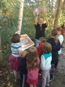
In the summer of 2018, Eagle Scout Alex Swanson approached the Pillsubry Free Library to ask if they would welcome a story walk starting at the library and extending along the rail trail from Depot St toward the covered bridge at Joppa Rd. Alex rose to the challenge of working with the Library, the board of Jim Mitchell Park, and the board of the Friends of the Concord-Lake Sunapee Rail Trail so the project would be in just the right locations. The walk opened October 5th, 2018 with a large crowd of attendees of all ages joining Alex and team for a Flashlight Night walk led by local author Matt Forrest Esenwine.


In February, the story walk shifted to a Winter theme with the addition of Deborah Bruss’s, Good Morning, Snowplow!
The library continues to update the story each month with stories tied into the seasons and events. Check out the trail to see the latest stories from our local and beloved authors.
The Exit 9 Project
The town’s first attempt to construct the rail trail near Exit 9 was in 2014. The town applied for a Transportation Alternatives Program (TAP) Grant.
Regrettably the town’s 2014 application was not awarded funding. In 2016 TAP was offered again, but the town did not apply. For the 2018 TAP round the town tried a different approach to link the village with businesses at Exit 9. They submitted a plan for a multi-use path along Rt 103.
That attempt also failed on a technicality, a person missed a required meeting so the application was not evaluated. But once again the town applied for TAP funding in 2021. Again it was for the multiuse path along Rt 103. And this time it was awarded funding by the state. However, the town has not yet approved to appropriate the matching funds.
In April of 2022 an opportunity presented itself to apply for Congressionally Directed Funding to build a project that would create trail connecting the eastern end of Waterloo St (just west of I-89 by Exit 9) to the businesses located near the Barbara Annis Roundabout (just east of I-89 Exit 9) and also create a bridge over the Warner River so the rail trail could run down the old right of way to the village. In late December 2022 we were awarded the grant! ** $1,203,000 in federal funding was included in the Omnibus bill at the end of 2022! See page 32 here. ** The project was discussed at a Warner Selectboard meeting on 1/31/2023. This was followed by a public hearing on March 7th. (Meeting minutes ) The topic was discussed again with the Selectboard on August 15th. And the town signed the sub agreement with the Friends of the Concord-Lake Sunapee Rail Tail at the Sept 5th Selectboard Meeting. The project has been added to the 2023-2026 NH Statewide Transportation Improvement Plan. (See project number 44161 on page 109) With the sub-agreement signed the Town was able to sign an agreement with NH Department of Transportation to begin the project.
5/2/24 Update: A very sincere thanks to the many Warner residents who participated in the 2024 Town Meeting when we asked for their support. We are pleased to report that NHDOT has approved HEB Engineers as the consultants for the Exit 9 project. They are starting the Engineering Study phase of the project in May of 2024. Matching funds raised by the Friends of the Concord-Lake Sunapee Rail Trail for the project are being placed into a dedicated account with the town.
7/18/24 Update: The slides from the Local Concerns meeting held July 16, 2024.
Comments (paraphrased) from the attendees:
Harry Seidel – I support the trail. Its important for safety, health and recreation. But it has to be done in a way the maintains and preserves the environment for animals. Residents will only enjoy the trail if they feel its not hurting the environment.
Barb Marty – Will the project build 2 bridges or one? What are the chances this project will get a categorical exclusion?
HEB: There is only enough funding to construct the bridge over Stevens Brook at this time. However, we are trying to design both the Stevens Brook bridge and the bridge over the Warner River and get permits for both. The reason is at the north bank of the Warner River on the east side of I-89 the trail and bridge abutment will intersect. This corner should be designed to accept a future bridge.
HEB: We do believe the project will qualify for a categorical exclusion.
Attendee (not sure who) – Will the trail allow ATV’s and snowmobiles?
Tim Blagden: The trail will not allow ATV’s. The machines tear up the stonedust. The way the FCLSRT works with snowmobiles is we leave the issue up to the landowner. If we can get snowmobiles onto the property at one end and off the property at the other end, and if the landowner wants to allow snowmobiles, then we are happy to work with the local club. If the landowner does not want snowmobiles we put up gates and leave them up in the winter. We do work with 4 snowmobile clubs along our overall trail.
Same attendee: I’m concerned that snowmobiles will be going close to my house and over my driveway which is part of the old railroad grade.
Tim Blagden: We have no plans at this time to use the railroad grade between I-89 and Waterloo covered bridge. We would need to have easements in place covering multiple properties and we have none of those in hand at this time. Waterloo St is much safer than being on Rt 103 and provides a reasonable route for the foreseeable future.
David Flanders: Why was a contractor crossing my property to dig a test hole without getting my permission?
Tim Blagden: I apologize for that. We thought the easement we had over the Warner Village Water District land behind your home included the right to reach that property. And I’ll say even if we do have the right to be there we would not build a trail between your home and garage. Its not the right thing to do.
David Flanders: Who is liable if someone breaks into my home?
Tim Blagden: The state of New Hampshire provides strong liability protection for landowners. Landowners have “zero duty of care” if they allow people to cross their property for recreational purposes. Its how hunting, snowmobiling and other trail activity is encouraged by the state which relies on the outdoor economy.
HEB: On the issue of the trail attracting a homeless population the evidence shows otherwise. The homeless move away from rail trails because they want to be left alone.
Christine Frost: Japanese knotweed is a serious issue. There is a lot of it between Warner and Bradford. Is there money in this project to control it?
HEB: Invasive species investigation is part of the project. We look for them in the corridor and may remove them as part of the project.
Attendee: When is the environmental work being done?
HEB: The environmental work has started. We’ve looked at online databases, IPaC, and others. Meetings with the Natural Heritage Bureau and Natural Resource Agency are being planned. At the next public meeting in the winter we will present what we’ve learned.
David Carroll: The homelss are not the only beings who flee from rail trails. Other living things also flee from them. You can’t build this trail to see wildlife and be a friend of nature. This project runs along the river’s edge and good trail building practices say you should run trails away from water sources. I’ve written 5 books on ecology, some are used as textbooks. I want to speak with your environmental staff. Your consultants’ job is to make projects work. My job is to protect the integral value. This is a rich floodplain habitat. This will interfere with migrating and nesting birds, with turtles – some of which may be declared endangered.
HEB: David, here is my card. We will arrange a time for you to speak with our staff. We know this is a sensitive floodplain. We are working not to follow the river and to stay high where the railroad was. By staying high we will have less habitat impact. I-89 has also disturbed this area.
David Carroll: This is part of a bigger project. Invasive species are an important issue.
HEB: There are invasive species here without the trail.
Sarah Allen: Looking at the map it seems ideal to move the trail away from the river and closer to I-89. Same with the bridge to point C. Keep that high where the railroad was.
HEB: The red line we showed on the slide is just one of several potential routes we are looking at. We are looking at routes that go closer to the I-89 southbound onramp. We will know more as we get into CAD topography review and design. Topography, barriers and environmental impact will all be part of the investigation and our presentation to you this winter. The bridge over the Warner River would lead to trail that stays very close to I-89 until it reaches the former railroad grade.
Christine Frost: Is parking part of the project at point A?
HEB: There is already a parking facility on the north side of Rt 103 and a crosswalk through the roundabout area to reach the south side. We will look at a safe crossing of the Evans driveway to reach the project, but the trail portion of the project starts on the west side of the driveway. We do not have a separate parking facility planned.
Tim Blagden: there could be potential parking at what is currently a NHDOT property on Waterloo St. An environmental assessment was done a few years ago and found no contamination at that time. But that is outside the scope of this project.
Bev Howe: Any maps going west? Why would you put trail users on Waterloo St and not just put them on Rt 103 as soon as you are west of the interstate?
Tim Blagden: Waterloo St is much safer for people walking and biking than being on Rt 103. In the area of this project the road just to the north of the project is the I-89 southbound onramp. We could never cross that. From Newmarket Rd east to the roundabout on Rt 103 is very uncomfortable and dangerous for walkers and bikers. Its the most heavily travelled non-interstate road we have in town, over 7000 cars a day.
How much money is being spent on this project?
Tim Blagden: $1.5 million. $1.2 million in Congressionally Directed Spending and $300,000 raised from private donations.
David Carroll: Cyclists are riding at night with LED lights. Some electric bikes and other devices go 39 miles an hour. This will further scare away wildlife and scare people off the trail.
Tim Blagden: Our easements allow regular bikes and category 1 & 2 e-bikes. Both of those e-bike categories are limited to 20 mph. We will work hard to keep higher speed devices off the trail as they make it uncomfortable for all other trail users.
Bev Howe: Who maintains the trail?
Tim Blagden: The Friends of the Concord-Lake Sunapee Rail Trail
Harry Seidel: What’s the width of the travel way on the bridge?
HEB: The bridge may have a 10′ width. The trail is likely to be 8 feet.
Tim Blagden: Or 9 feet on the trail. We would prefer 9 feet.
Harry Seidel: Will the running surface of the bridge be concrete or stonedust?
HEB: It will be a slip resistant planked surface. The trail will constrain in width as needed in certain areas and be sensitive to needs.
David Carroll: I heard the trail was 14 feet wide with 2 foot berms on either side. Is this not correct?
Tim Blagden: We typically build with a 9-10 foot wide trail surface and then clear an additional two feet on either side so people have space to step off the trail to rest or watch wildlife. There is not a two foot high berm.
Sarah Allen: Going under I-89 how do you deal with flooding?
HEB: If the trail is benched into the existing riprap cross slope we would create a stable wall on the downslope side below the trail. This could be cement or redi-rock. Those sorts of design details are made after engineering study is complete. We are paying close attention to the flood maps and aim to build out of the water’s way.
Harry Seidel: Will the trail meet ADA standards for trails?
HEB: Yes.
Tim Blagden: We use a 3/8″ minus trail mix that firms up and is smooth for wheelchairs and personal mobility scooters. You can experience the difference between 3/4″ minus and 3/8″ minus at Bagley Field. To the right of the driveway is 3/4″ minus put down in 2014. To the left of the driveway we used 3/8″ minus put down in 2017.
Attendee: Are we coordinating with Eversource?
HEB: Yes.
Attendee: Will the CLSRT.ORG website be updated?
Tim Blagden: Yes. HEB will send us the slides.
Christine Frost: Can the trail be hung off the I-89 bridges as its passes underneath?
HEB: No. The bridge structural elements are not designed to support a trail hanging from them.
Barb Marty: What are the plans for fencing?
HEB: We don’t plan to fence other than where necessary for trail user safety. The bridge will have railings. The trail under I-89 may have a fence if there is a drop on the downslope side.
Attendee: Are you aware there is a septic system under the railroad grade near Waterloo covered bridge?
Tim Blagden: We have no plans to use the railroad grade in that area at this time. Trail users will be on Waterloo St.
Attendee: People are not going to want traffic on Waterloo St either.
Bev Howe: People on Waterloo St don’t want their street to become a rail trail.
Tim Blagden: Waterloo St is a public right-of-way. We have the right to be there and intend to use the street. The people have to follow the rules of the road. Our users will not be going faster than 20 unless they can pedal that fast. We also don’t believe this short section of trail will lead to a significant increase in traffic. Most users are likely to be residents of Waterloo St and nearby streets like Newmarket, Willaby-Colby, East Sutton Rd, Retreat Rd.
Clyde Carson: In Warner the Selectboard makes the decisions about whether snowmobiles can be used on the streets and so far has said no.
HEB: We will be back at the conclusion of the engineering study to present our findings.
The LPA Process: NHDOT has a process for locally managed projects. Its called Local Public Agency or LPA. The Exit 9 project is an LPA process project. You can read about it here. NHDOT has a presentation that makes it possible to follow along with the process. Intro. Administration. QBS. Engineering Study. Preliminary Design. Final Design. Bid Phase. OIG Fraud. Construction Part 1. Construction Part 2. LPA Handouts 297 pages.
Requests for Qualifications were solicited from consultants during October of 2023. Six firms responded. A committee consisting of Selectman Allan Brown, Finance Director Clyde Carson, DPW Director Tim Allen, and FCLSRT board member Tim Blagden reviewed the qualifications. We ranked those firms and reported our findings to NHDOT. We received authorization from NHDOT in February 2024 to proceed with negotiations of scope and fee for the consultant. Negotiations continued through Feb, March and into April of 2024 when we received notification to proceed from NHDOT to sign the contract with our selected consultant, HEB Engineers. They are beginning to work as of May 2024. There will be a number of public hearings and planning sessions as the engineering study phase and preliminary design phase progress. The Exit 9 project itself is well under a mile, but the connections it makes enable people to use miles of lower stress roads to reach a lot of places people want to get to for work, necessities, or fun. Here’s a video discussing the project.
Historic development in the area near Exit 9. We’ve merged and colored a few pages of the I-89 design drawings to show you where the Warner River and Stevens Brook used to be (they’ve been moved!), where the roads used to be, where the railroad was, and where we might be able to place a trail, using some of the remaining railroad grade. We are trying to show we are re-using what we can while providing a safe, pleasant, convenient way to to get from one side of the interstate to the other without having to drive.
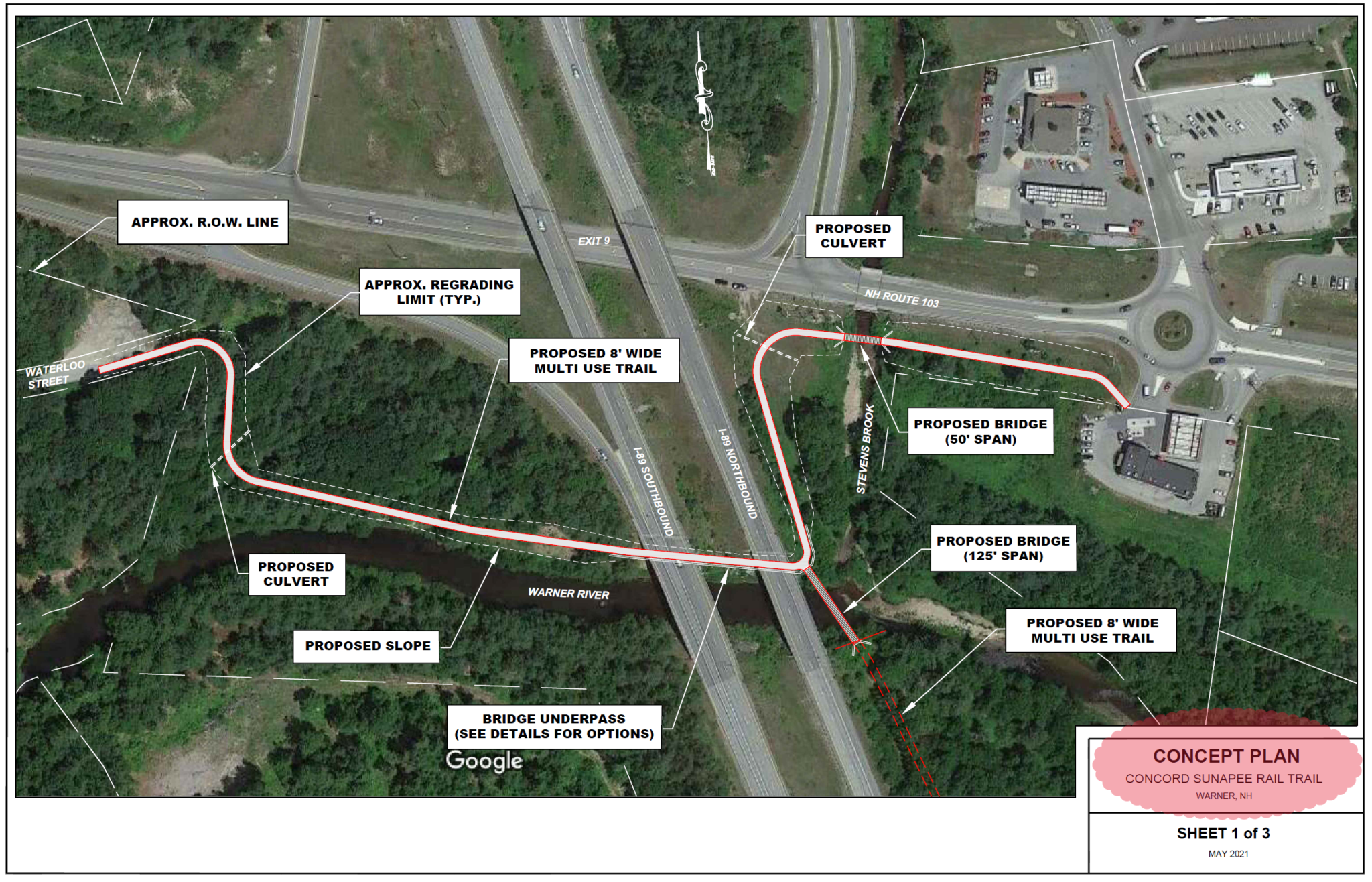
Its very important to understand the above image describes the Exit 9 project in general terms. In general terms it hopes to create a safe accessible trail in the state right-of-way from the end of Waterloo St to the roundabout and include a bridge over the Warner River which will link to additional easements extending toward the village.

The orange in the picture above shows again the goals of the Exit 9 project. Use Waterloo St (instead of being on Route 103) to get under Interstate 89. Then have a trail spur to reach the businesses at the Intervale area of Warner. Also have a bridge over the Warner River. Shown in lighter yellow color is the old railroad grade. The Friends of the Concord-Lake Sunapee Rail Trail have an easement over the portion of this that is outside of the NHDOT Limited Access Right-of-Way. That would make a connection with Willy Lane. From there using Willy Lane and Chemical Road and Depot St will bring you to downtown Warner and the Story Walk section of the rail trail.

Many people who are considering making a trip by bike think about the portion of the trip that scares them the most. If the perceived risk is too great they will either do the trip another way (in a car) or cancel the trip. This Exit 9 project directly addresses the highest traffic stress portion of the journey for people currently trying to reach the Intervale by bike. People who live on all those side roads in blue on the picture may be a lot more inclined to bike to the Intervale businesses and downtown businesses if this project materializes.
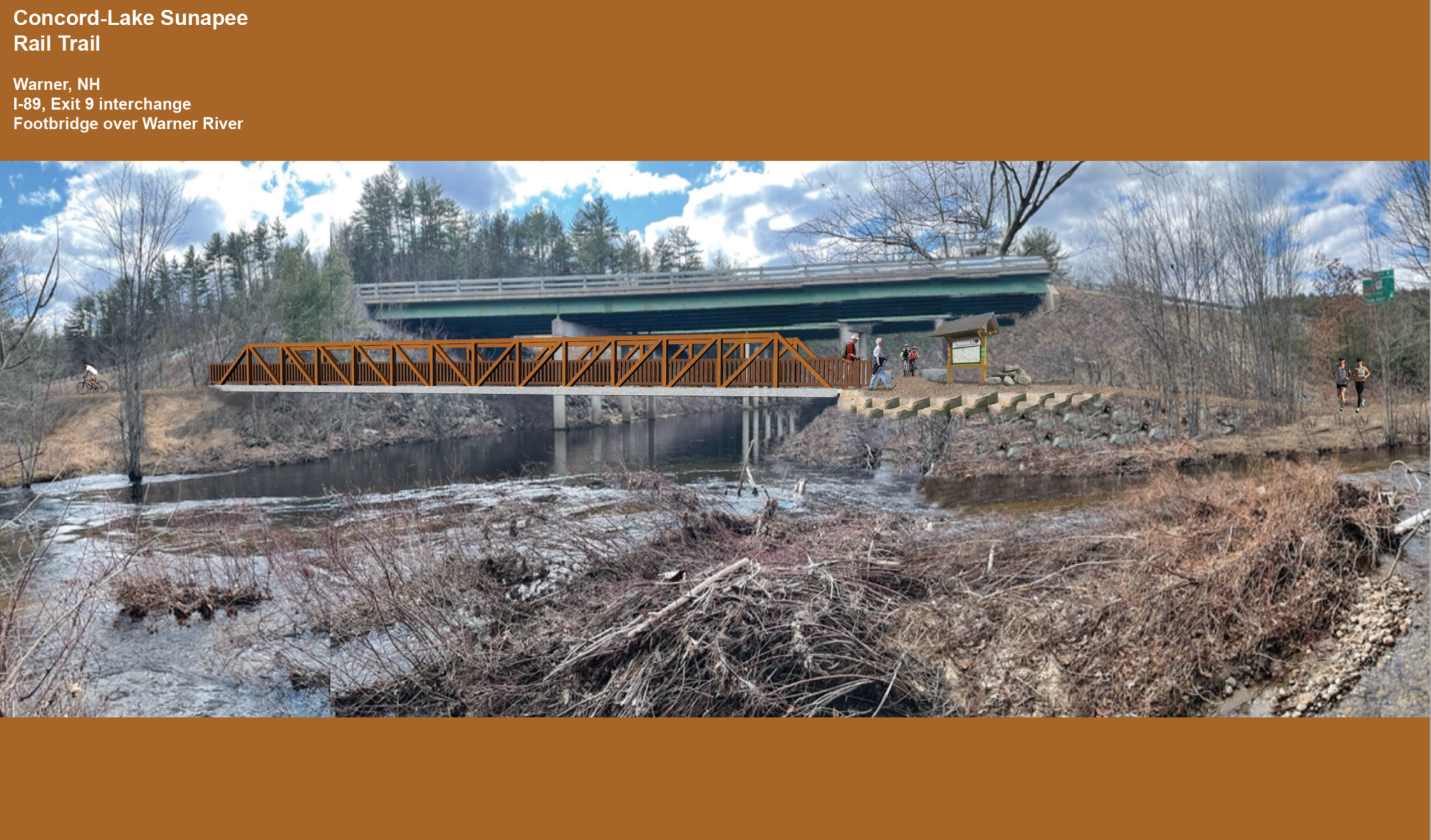
The image above(created using photoshop to insert the pedestrian bridge and trail) is looking west from a spot on the Warner River just downstream of where Stevens Brook joins the river. You see the I-89 northbound bridge in the background. A pedestrian/bicyclist bridge is shown just downstream from the highway. Trail to downtown Warner village would be on the left. Trail to Waterloo street would pass under the highway from the righthand end of the pedestrian bridge. A spur trail heads toward Rt 103. Just out of sight it would turn right, cross over Stevens Brook, and bring you to the roundabout where there are existing sidewalks, a crosswalk, and a section of multiuse path.
For additional information, download the 2009 Safe Routes to School Travel Plan prepared by Central NH Regional Planning. Almost all of the issues highlighted in that plan are still relevant today.
Other Warner Projects
We continue to talk with the private landowners who own much of the former railroad grade. Its their land and we support their right to do what they want with their property. (We really mean that!) As we have additional projects to announce we will add them.