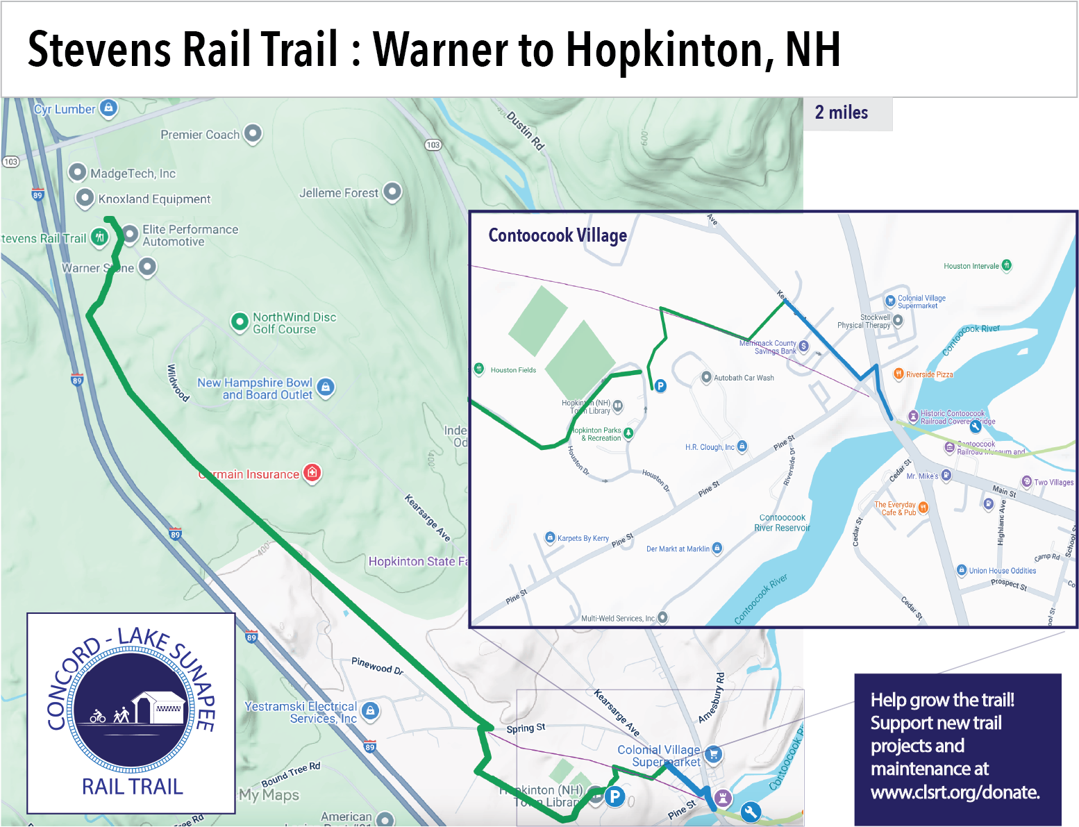
Stevens Rail Trail – Warner Exit 7 Davisville to Hopkinton
In Warner, park to the right of the trail gate alongside Old Warner Road in Davisville. In Hopkinton, park to the right of the Hopkinton library by the kiosk and walk/ride along the back access road to the intersection of Spring Street and Krzyzaniak Lane. Cross the road here and you will see orange trail gate. In 2024 an extension from the library to Kearsarge Ave in Contoocook village opened.


Bradford – Tilly Wheeler Trail and Lower Lake Todd


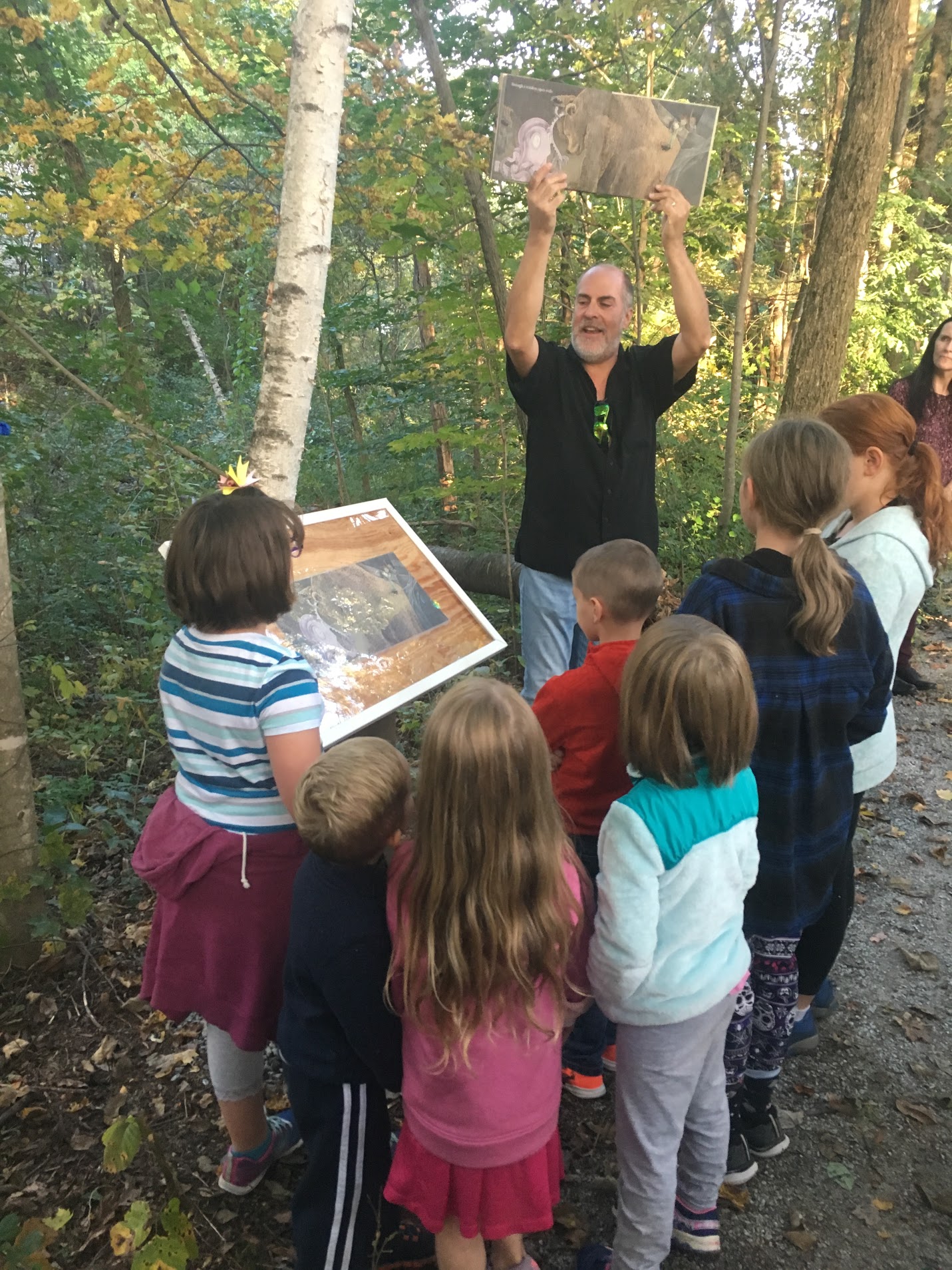
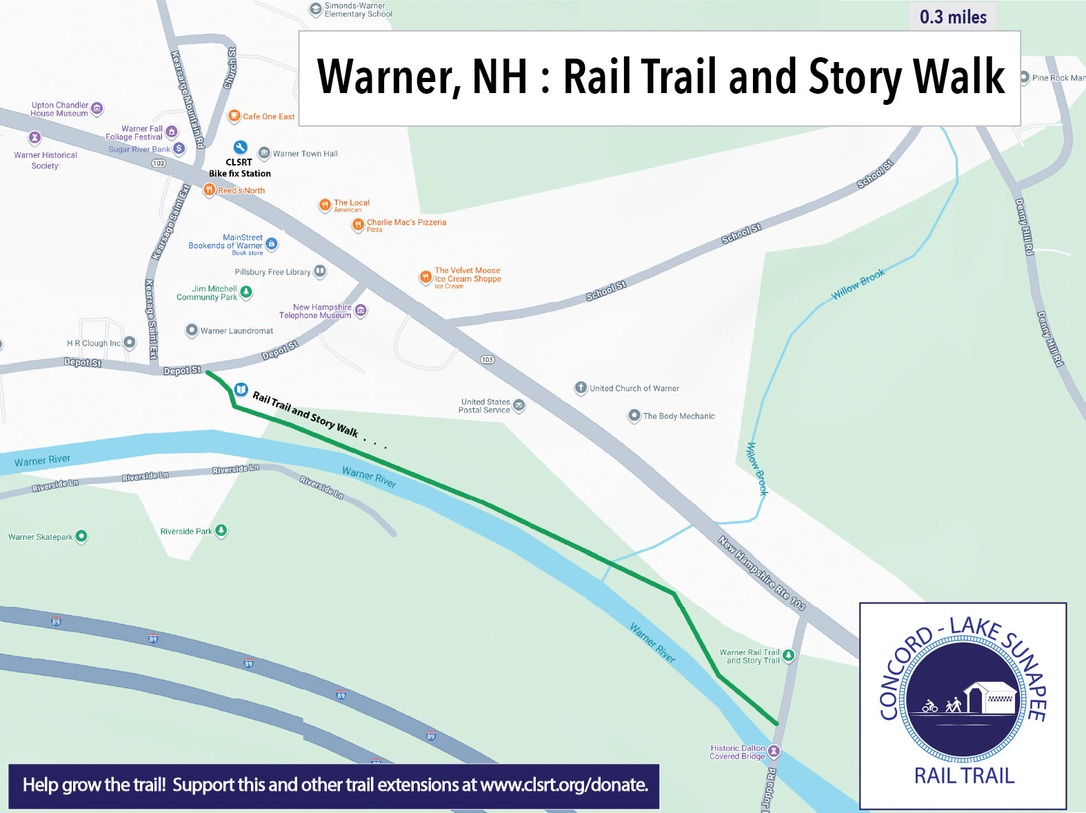
Warner story walk – Depot Street to Joppa Covered Bridge


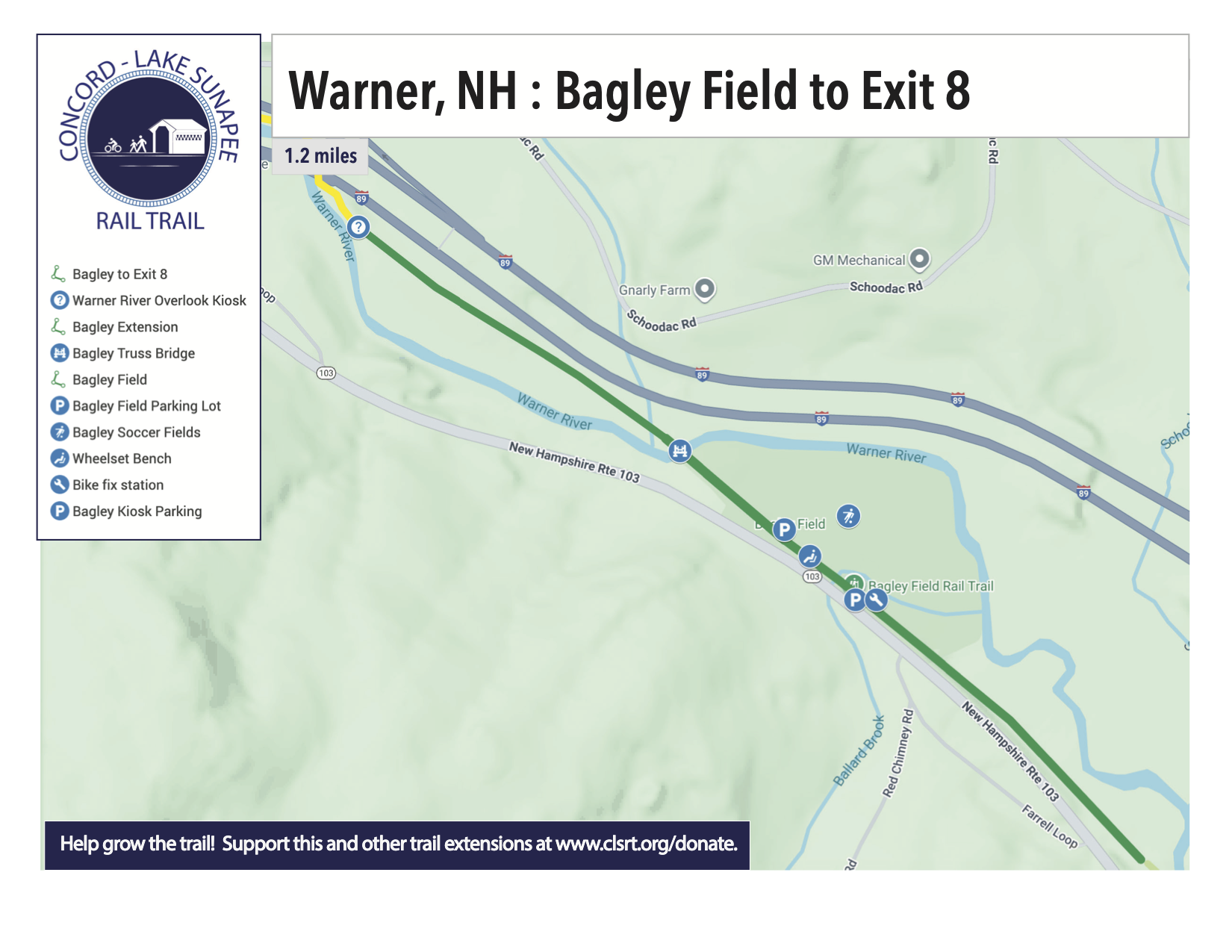
Warner Rail Trail at Bagley Field in Warner, NH
This section of trail was extended by a half a mile to the west and now brings you to another view of the Warner River.


Concord, NH Fisherville Road to Carter Hill Road


The parking area at 25 Fisherville Rd, Concord, NH is now open. You will find parking for 7 vehicles, a bicycle fix station with pump, and a kiosk with trail information. This section of trail was built over a 6 year stretch with the first segment opening in March of 2020 just as COVID hit. The final (orange) segment constructed in the first half of 2025.

Is this section of the rail trail owned by the State of NH & managed by DOT?
Avis, This trail is not owned or managed by the state.
Hello,
Is there one map that shows all sections with their current status?
Thanks,
Tom
Tom, We don’t have a single map showing all sections. We have to be very respectful of private property owners who have not yet decided to work with us. We don’t want to be seen guiding people onto their property. We will be adding a map of the Concord section from Fisherville Rd to Carter Hill Rd in the next week. Otherwise, sections of the trail we have improved are on the website. I hope this helps.
Hey there thank you for this! Could you include a searchable address for parking at all the trails. This would be a big help! Thx:)
Good suggestion. We will put this on the to-do list to get it done shortly.
I am interested in the plans specifically from the Concord/Fisherville trail. We rode the trail yesterday and it seemed to come to an abrupt stop next to a store by Horse Hill Road. We couldn’t figure out where to go next as there was no signage to direct us. Could you please advise where the trail goes from there?
Janet,
Over the long term we hope to build a connection from Carter Hill Rd to Lehtinen Park on Horse Hill Rd. But we don’t have access to the private property we would need to make this connection. In the mean time you can take Carter Hill Rd to Horse Hill Rd for an on street connection. Please always respect the rights of the private property owners.
Hi Tim
It’s been a couple years, and I think this is just the canoe rental place in the way, who should be on board with the rail trail. What’s the update? Thanks!
Greg
Greg,
The railroad grade is on City of Concord property adjacent to Contoocook Kayak and Canoe. The city has given us permission to explore building trail on that parcel. The former railroad grade is very wet close to Horse Hill Rd. So at the moment we are focusing our attention on the other side of the river at the Pump Station 5 parcel. We are also working on a section of trail further up Horse Hill Rd.
Tim
I’m looking forward to exploring much of the line and I’m very appreciative of the work you’re doing here. I just published a short article and map on the Old Rail Trail on the Mast Yard State Forest section at Trailspotting.com, with more to follow.
https://www.trailspotting.com/2021/11/mast-yard-rail-trail.html
Hi:
I live in the Vineyards just off Bog road and a mile from this section of the Concord-Lake Sunapee trail. I have walked and biked the trail several times and it is always enjoyable. (Actually I am even closer if I could take the Bull Meadows drive.)
Since I am so close, do you need any volunteers for maintenance of this section of the trail between the Fisherville Road parking area and Carter Hill road? If so I would be glad to help.
Hi Rod,
We will be looking for some volunteers along this section. We just completed phase three of the Fisherville Rd to Carter Hill Rd section and plan on building the remainder to Carter Hill later in 2023. Come visit us at Market Days June 22-24 on Main St in Concord or send us an email at info@clsrt.org and we can figure out what would be fun for you to do.
Hello, We just discovered this wonderful trail and biked yesterday from the Hopkinton library to Davisville and back. We enjoyed the spur trails; what fun! We were fortunate to see a barred owl along the Hemlock Loop. The trail was short, though – does it not continue on yet? Are there any longer sections, and is this still an active project?
Hi Diane,
Glad you enjoyed the trail. When you reached the gate at Spring St in Contoocook there is a way to cross Spring St to reach the Hopkinton Playing Fields and then continue on their dirt drive to the Hopkinton Library. In the fall of 2023 the trail will continue from the library to Kearsarge Ave. We are continuing to develop new sections of trail as we gain access to land from the landowners. Follow along as we make progress. We strive to build at least one new section every year.
Hi,
Thanks for this WONDERFUL bike trail! It would be great if on each map you indicated milage one way, so people could choose how long of a ride they want to do. Thanks!
-Heidi
Heidi,
Great suggestion. As we refresh maps we will add the one-way mileage.
What is the actual address to get to this trail? When I put it in the GPS it doesn’t come up..
This trail is coming together in short separate sections. Trailheads are at 25 Fisherville Rd, Concord NH; 60 Houston Dr, Contoocook, NH (Hopkinton Library); Bagley Field Rail Trail in Warner, High St at Route 103 in Bradford.
Where can I find a detailed “trail plan” for the trail from Contoocook village to Mast Yard Forest?
There is a lot of private property between Contoocook Village and the Mast Yard that we do not have access to. Please be very respectful of private property. We look forward to the day when we can post a route, but we aren’t there yet.
I added everything that’s listed on this page to OpenStreetMap. Here is the route: https://www.openstreetmap.org/relation/7300836
Russ, Thank you for your efforts with Open Street Map. In the section that starts in Concord and runs west to Penacook Rd in Hopkinton you show the trail going all the way to Penacook Rd. We do not have an agreement with the western most landowner in that stretch. Is there a way you can trim back the red line to not include the last parcel? See tax maps at https://next.axisgis.com/HopkintonNH/ and exclude parcel 242-021-000. We have to be super respectful of private property owner rights.
Please also exclude 242-012-001, if you have not aleady. Thank You!
Russ – thanks for linking the map; the best one I’ve seen.
Tim – we are also in the neighborhood along Penacook Rd. At some point, we’ll need to have a discussion around the “vision” for this particular stretch of trail.
Great resource! Is it ok to park at the Carter Hill road end of the Concord section?
We are working to establish parking on the Pump Station 5 property at the beginning of Broad Cove Rd. We (the Friends of the Concord-Lake Sunapee Rail Trail and the City of Concord) both think parking on Carter Hill Rd at the trail head will lead to crashes.